
Every surveyor in Nigeria knows the struggle (long distances between sites, heat, thick bush, and clients who want their coordinates like yesterday). In situations like this, your instrument is either your best helper or your biggest delay.
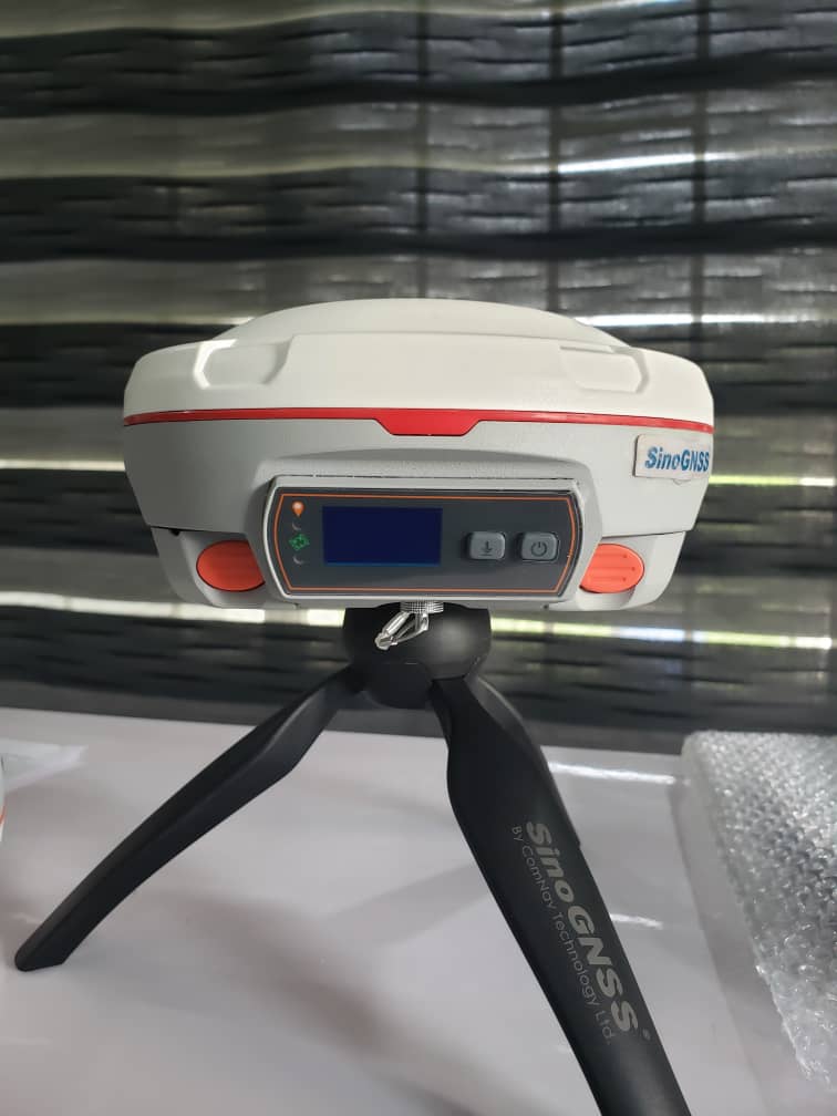
This is where the SinoGNSS T30 Receiver comes in. Surveyors, engineers and construction firms in every corner of Nigeria, from the coast to the north and every region in between, are switching to SINOGNSS T30 Receiver through its authorized dealer, OTIC Geosystems. It is compact, rugged, and precise when the job demands it. We call it the ODOGWU Receiver.
SinoGNSS T30 Receiver Features and Specifications
Full-constellation tracking for reliable fixes under canopy
The SinoGNSS T30 Receiver tracks 1,198 channels across GPS, GLONASS, BeiDou, Galileo, SBAS and L-Band. Paired with its advanced positioning algorithm, this keeps your signal steady, so you can still get a good, fixed solutions when you are working under trees.
IMU tilt compensation for measuring with a tilted pole
The SinoGNSS T30 Receiver has a built-in IMU that lets you measure without levelling the pole, with tilt compensation from 60° to 120°. This saves real time during topographic surveys, boundary work and stakeout, especially beside walls, fences and building corners.
Works with CORS, Drones, and Echosounders
You can use the SinoGNSS T30 Receiver for network RTK through CORS, Aerial mapping with Drones, and Hydrographic work with an Echosounder, all from one receiver. The built-in 4G modem works with CORS networks, so you receive corrections over the internet instead of setting up your own base station. In areas and states covered by the OTIC CORS network, that means fewer items to carry to site and faster setup.
Compatible with Tersus, Kolida, Hi-target and other brands
Already own receivers from another brand? All SINOGNSS receivers support standard RTCM corrections, so it can work as a rover on a Tersus, Kolida, or Hi-target base, or serve as a base for their rovers as well.
Standalone accuracy of 10cm to 40cm with PPP
When there is no base or CORS coverage, PPP support lets you still work with decimeter-level positioning in remote locations.
Built for field conditions
The housing is magnesium-aluminum alloy, rated IP67 for dust and water, and designed to survive a 2m drop onto concrete.
Long working hours
Work for up to 3 days as a rover on a single charge. The SinoGNSS T30 Receiver comes with two 3400mAh hot-swap batteries, so you can change power without switching off and never lose your setup mid-job.
Light and portable
It weighs 1.2 kg with both batteries and measures about 15.5 cm × 7.3 cm, which matters over a full day on the pole.
Simple software workflow
The SinoGNSS T30 Receiver works with Android-based Survey Master software, which offers a wizard-style workflow and supports Static, PPK and RTK survey modes, plus surface stakeout and mapping survey.
What Can You Use the SinoGNSS T30 Receiver For?
It suits independent surveyors starting out, as well as firms running several crews at once. Typical applications include:
Cadastral and boundary surveys
Topographic surveys
Estate and layout surveys
Construction and road stakeout
Mapping and GIS data collection
Drone-based mapping and hydrographic surveys with an echosounder.
Where to Buy the SinoGNSS T30 Receiver in Nigeria
OTIC Geosystems is the authorized dealer of the SinoGNSS Receivers in Nigeria. Every purchase comes with:
Flexible payment plan
Technical support
Free training
Access to all OTIC CORS stations
Ready to Work Smarter?
Every hour spent levelling poles, setting up a base, or waiting on a weak signal is an hour that could be put to good, billable use. The SinoGNSS T30 Receiver is built to give that time back. Talk to us today and see how it fits your work.
Talk to OTIC Geosystems today:
Click here to message on WhatsApp.
Phone: +2348085041173
Visit OTIC Geosystems or explore our product shop.