
Survey Equipment: The Technology Behind Accurate Decisions
Every successful infrastructure project begins with reliable information about the environment in which it will be built. From establishing property boundaries and constructing roads to mapping agricultural land and monitoring industrial facilities, surveying equipment provides the measurements and spatial data needed to plan, execute and manage projects effectively.
Today, surveying extends beyond conventional land measurement. Modern geospatial technologies combine satellite positioning, optical instruments, laser scanning, aerial mapping and digital data collection to support industries that depend on accurate spatial information.
At OTIC GEOSYSTEMS, we recognize that choosing the right equipment is about more than purchasing an instrument. It is about identifying the right technology for a specific task, understanding its capabilities and integrating it into a reliable workflow.
Here are some essential categories of survey equipment, examples of available technologies and the industries they support.
1. GNSS Receivers: Precision Positioning Across Industries
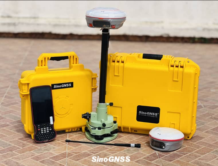
Global Navigation Satellite System (GNSS) receivers use satellite signals to determine positions on the Earth’s surface. When configured with suitable Real-Time Kinematic (RTK) corrections, they can provide centimeter-level positioning under favorable conditions.
They are essential for land surveying, engineering, construction setting-out, mapping and infrastructure development.
ComNav Jupiter Laser RTK GNSS Receiver combines satellite positioning with laser measurement, inertial measurement and dual-camera technology. Its laser can measure points up to a specified range of 50 meters, helping surveyors capture inaccessible or obstructed points without placing a survey pole directly on every target. Its camera-assisted visual stakeout also supports guided positioning on the ground.
In practice, this technology can support:
i. Construction and engineering: Setting out building corners, road alignments, structural points and other design coordinates.
ii. Oil and gas: Mapping pipeline corridors, locating infrastructure assets and surveying challenging project sites.
iii. Urban planning: Collecting coordinates for roads, utilities, land parcels and public infrastructure.
iv. Agriculture: Mapping farm boundaries and recording georeferenced field information.
v. Mining: Surveying accessible control points and supporting site development.
For professionals who need a compact, portable alternative, ComNav T20 Palm GNSS Receiver offers a lightweight design with integrated tilt compensation. It is suitable for land surveying, GIS data collection, agriculture and machine-control workflows.
The Jupiter and T20 illustrate how different receiver designs can serve different operational needs—from laser-assisted measurement in difficult locations to portable positioning for routine fieldwork.
2. Automatic Levels: Reliable Elevation Measurement
Not every survey task requires satellite positioning. Establishing differences in height remains fundamental to construction, road engineering, drainage and infrastructure development.
Automatic levels use an optical telescope and compensator to establish a horizontal line of sight for elevation measurements.
ComNav DS4-SN36 Automatic Level is designed for levelling applications in construction, mining, roads and bridges. Its specifications include a 36× magnification telescope and a stated standard deviation of 1 mm per kilometer of double-run levelling under the specified test conditions.
Its applications include:
i. Construction: Checking foundation levels, floor elevations and formation levels.
ii. Road and bridge engineering: Establishing Road profiles, drainage gradients and structural elevations.
iii. Oil and gas: Supporting elevation surveys for pipeline infrastructure and industrial facilities.
iv. Urban development: Measuring site levels for drainage design, grading and development planning.
v. Mining: Supporting levelling work for haul roads, platforms and site infrastructure.
Selecting a suitable levelling instrument depends on the required accuracy, field conditions and survey methodology. Proper setup, staff readings and established quality-control procedures remain essential.
3. 3D Laser Scanners: Capturing Detailed Spatial Information
Laser scanning enables professionals to collect dense three-dimensional measurements of buildings, terrain, industrial facilities and other physical environments. The resulting point clouds support modelling, measurement, documentation and spatial analysis.
ComNav LS600 3D Laser Scanner combines LiDAR, inertial measurement, GNSS positioning and dual cameras to produce detailed, colorized point clouds. Its handheld design and scanning capabilities support applications in surveying, urban renewal, mining and emergency response.
For larger mobile mapping operations, ComNav ML300 Mobile Laser Scanning System integrates LiDAR, positioning technology and panoramic imaging to capture road corridors and surrounding environments. Its applications include road-asset extraction, urban forestry, power-distribution-line analysis and smart transportation.
These technologies can support:
i. Construction and engineering: As-built documentation, structural measurements and building information modelling workflows.
ii. Oil and gas: Documenting industrial facilities, existing structures and complex asset environments.
iii. Urban planning: Mapping streetscapes, buildings, road infrastructure and utility corridors.
iv. Mining: Capturing site geometry and supporting volumetric analysis.
v. Infrastructure management: Creating detailed spatial records for inspection and maintenance planning.
The choice between handheld and mobile scanning depends on the project scale, required level of detail, access conditions and accuracy requirements.
4. Hydrographic Equipment: Surveying Beneath the Water
Geospatial data is equally important in rivers, reservoirs, ports and coastal environments. Hydrographic equipment measures water depth and helps professionals map underwater terrain for engineering, navigation and resource management.
ComNav HYD10 Portable Echo Sounder uses acoustic measurements to determine water depth and can be integrated into suitable positioning and hydrographic survey workflows. Its published depth range is 0.3–200 meters, subject to operating conditions and configuration.
For more automated operations, ComNav SV600 Unmanned Survey Vessel integrates GNSS positioning, depth measurement and vessel-control technology to support the collection of underwater terrain data. Depending on configuration, it can also accommodate additional sensors for specialized survey tasks.
These systems support:
i. Civil engineering: Surveying rivers and reservoirs for infrastructure planning.
ii. Oil and gas: Supporting bathymetric surveys for relevant coastal and water-crossing projects.
iii. Urban and environmental planning: Mapping water bodies and supporting drainage assessments.
iv. Ports and dredging: Measuring channel depths and monitoring underwater terrain.
v. Water-resource management: Supporting reservoir surveys and related monitoring activities.
Accurate hydrographic results require appropriate positioning, calibration, water-level information and survey procedures—not just a depth-measuring instrument.
5. Precision Agriculture and Machine Control
Modern agricultural operations increasingly rely on positioning technology to improve the consistency of fieldwork and support more efficient use of resources.
ComNav AG601 Pro Autosteer System combines high-precision GNSS positioning, software and machine-control technology to support guided agricultural operations. It is designed to help operators manage field passes more consistently and reduce unnecessary overlap during suitable farming activities.
Its applications include:
i. Crop production: Supporting guided planting, spraying and harvesting operations.
ii. Large-scale farming: Improving repeatability across extensive fields.
iii. Agricultural engineering: Integrating positioning and guidance technology with compatible machinery.
iv. Land management: Supporting consistent field operations and spatially informed farm planning.
GNSS receivers can complement these systems by mapping farm boundaries, recording sampling locations and georeferencing agricultural information. Together, these technologies help connect field operations with data-driven agricultural management.
Choosing the Right Survey Equipment for Your Project
The most suitable instrument depends on the work to be completed, the environment in which it will operate and the accuracy required.
Before investing, consider the following:
i. Project requirements: Determine whether you need positioning, elevation measurement, aerial mapping, 3D documentation or bathymetric surveying.
ii. Accuracy and specifications: Match the instrument’s documented capabilities to the project’s tolerances and deliverables.
iii. Field conditions: Consider terrain, satellite visibility, access restrictions and environmental conditions.
iv. Software compatibility: Check that the equipment supports your required data formats and CAD, GIS or engineering workflows.
v. Training and technical support: Evaluate commissioning, professional training, maintenance and access to technical assistance.
In many cases, combining technologies provides a more complete solution. GNSS receivers can establish survey control, levels can transfer elevations, and laser scanners can document complex structures.
OTIC GEOSYSTEMS: Your Trusted Partner for Geospatial Solutions
The value of surveying equipment lies not only in its technical capabilities but also in how effectively it is selected, deployed and used.
OTIC GEOSYSTEMS supports surveying professionals, engineering firms, government institutions, universities and other organizations with geospatial equipment, professional training, technical support and infrastructure solutions. Our focus is on helping customers identify suitable technologies for their operational needs and build the capabilities required to use them effectively.
Whether you are planning a construction project, mapping agricultural land, developing infrastructure or undertaking specialized surveying, having a reliable geospatial partner can make the equipment-selection process more straightforward.
Explore surveying equipment and geospatial solutions through the OTIC GEOSYSTEMS online shop: www.oticgs.com/ng/shop.