
Imagine you have just been awarded a contract to survey a 500-hectare piece of land for a new estate. You need to establish boundaries, collect coordinates, map access roads and prepare the site for development. If you are a land surveyor, construction professional or engineering consultant, you know that choosing the right surveying equipment can affect your project's cost, speed and productivity.
The answer depends on your project requirements, but GNSS technology offers important advantages for surveying large, open areas. Now ask yourself: would you prefer to use a GNSS receiver such as SinoGNSS, CHCNAV, Leica, Foif, Trimble or a total station from brands such as Leica, Trimble, FOIF or Topcon?
For many surveyors working on large, open sites, a GNSS receiver can make the job faster and more convenient. Unlike a conventional total station, which generally requires a clear line of sight between the instrument and the target, a GNSS receiver determines positions using satellite signals and suitable correction data. This can allow surveyors to collect coordinates across large sites without repeatedly setting up an instrument at different stations. But does that mean total stations are no longer useful? Absolutely not! The best choice depends on the job, the site conditions and the accuracy requirements.
At OTIC GEOSYSTEMS, we believe surveyors should have access to equipment that helps them work efficiently without unnecessarily stretching their budgets.
What Makes SinoGNSS Receivers a Practical Choice?
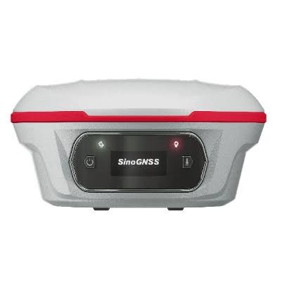
The SinoGNSS Jupiter Laser RTK combines satellite positioning with laser measurement, visual technology and tilt compensation.
Key specifications include:
GNSS tracking: Multi-constellation satellite support.
RTK accuracy: Approximately 8 mm + 1 ppm horizontally and 15 mm + 1 ppm vertically under specified conditions.
Laser measurement: Up to 50 metres.
Tilt compensation: Supports measurements at up to 120° of tilt, with specified accuracy of approximately 2.5 cm.
Visual positioning: Integrated dual cameras for visual surveying and stakeout workflows.
Battery life: Up to 16 hours under specified operating conditions.
Connectivity: Bluetooth, Wi-Fi, USB Type-C and supported UHF radio options.
These features can help surveyors work more flexibly, particularly when collecting points around obstacles or moving between survey locations. Actual performance depends on field conditions, equipment configuration and correction services.

But What About Leica, Trimble, FOIF and Topcon Total Stations?
Let's be realistic: these brands offer established surveying instruments, and total stations remain extremely important.
Suppose you are setting out columns inside a building in Dubai. Satellite signals may be obstructed, and you need to transfer precise positions from a building grid. A total station may be the better tool because it measures angles and distances to a target using a clear line of sight.
Now consider a large residential estate in Ghana, where you need to collect hundreds of boundary coordinates across open ground. An RTK GNSS receiver could help you move between points without repeatedly setting up a total station.
What if you are working on both types of projects? You may benefit from having both GNSS and a total station available.
The key difference is that GNSS is often advantageous for large, open-area surveys, while total stations remain essential for many precision tasks in obstructed environments. Many professional surveyors benefit from using both technologies.
The goal is not to eliminate total stations. It is to choose the right equipment for each task.
Why Are Surveyors Considering SinoGNSS for Large Projects?
Let's take a practical example.
You are surveying a long road project that stretches several kilometres. With an RTK GNSS receiver, you can collect coordinates along suitable sections of the route using satellite positioning and an appropriate correction service. You do not need to establish a new total station setup every time you move to another section.
Compare this with a total station workflow, where you may need to establish instrument stations, maintain a clear line of sight and move or resect the instrument as the survey progresses.
On a large, open site, GNSS can reduce setup requirements and help your team cover more ground efficiently.
Now imagine surveying a large agricultural farm in Australia or mapping undeveloped land in Namibia. A GNSS receiver can be especially useful for collecting boundary points, mapping features and establishing coordinates across open terrain.
That is where a solution such as the SinoGNSS Jupiter Laser RTK becomes worth considering.
Benefits for Surveyors Worldwide
From the United Arab Emirates and United Kingdom to Australia, South Africa, Angola, Benin Republic, Namibia, Tanzania, Zimbabwe, Sierra Leone, Ghana, Malawi and Egypt, surveying professionals face pressure to deliver accurate results while managing equipment and operational costs.
SinoGNSS offers an option worth considering for land development, road construction, topographic mapping, agriculture and infrastructure projects. Its easy-to-use workflow, advanced positioning features and budget-conscious positioning may help surveying businesses improve productivity without automatically investing in the most expensive equipment available.
GNSS receivers can also work with compatible correction services and data formats from different manufacturers. However, interoperability with Leica, Trimble, Topcon, FOIF, Sokkia and other GNSS systems depends on supported protocols, software and configurations. Confirm compatibility before purchasing.
We Want to Hear From You!
We want to hear from surveyors and engineering professionals.
Tell us:
Which GNSS brand are you currently using; SinoGNSS, Leica, Trimble, Topcon, CHCNAV or another brand?
Which total station do you use; Leica, Trimble, FOIF, Topcon, Sokkia or another manufacturer?
For a large estate, highway or agricultural project, would you prefer GNSS or a total station, and why?
What matters most to you: accuracy, speed, ease of use, compatibility, after-sales support or price?
Share your experience in the comments. Your feedback can help other surveyors make informed equipment decisions.
Interested in purchasing a GNSS receiver or total station?
Contact OTIC GEOSYSTEMS for product information, pricing and assistance choosing equipment for your projects.
WhatsApp: +971 52 622 8783
Email: info@oticgs.com
Whether you prefer GNSS, total stations or a combination of both, let's find the right surveying solution for your next project!