

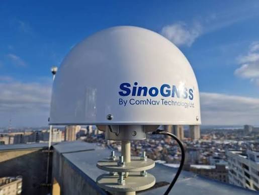
For Surveyors across United Arab Emirates, United Kingdom, Australia, South Africa, Angola, Benin Republic, Namibia, Tanzania, Zimbabwe, Sierra Leone, Ghana, Malawi, Egypt, CORS (Continuously Operating Reference Station) has become an important part of high-accuracy GNSS positioning by delivering real-time kinematic (RTK) corrections directly over cellular networks or IP connections. Field teams no longer need to carry, guard or set up expensive physical base stations on large infrastructure projects but with different CORS providers and subscription models available, an important question remains: How reliable is CORS for surveyors in different countries?
What Is CORS?
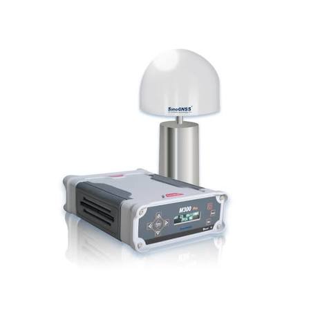
CORS means Continuously Operating Reference Stations which are designed to support continuous GNSS reference-station operations for high-accuracy positioning. The SinoGNSS M300 Pro 2025, for example, uses the K8 platform and tracks 1,590 channels across GNSS constellations including GPS, GLONASS, BeiDou, Galileo, QZSS, IRNSS, and SBAS. It is described as a GNSS solution designed for multi-purpose reference station and other high-accuracy positioning applications. The receiver also supports long-term raw-data recording, Ethernet connectivity, standard formats like RTCM 2.X, RTCM 3.X, RTCM 3.2, CMR, BINEX, NMEA-0183 and compatible with major CORS software including VRS, FKP, iMax and multiple data-transfer formats. It is designed for continuous operation, with an integrated battery that can serve as primary power or UPS backup.
Why Should Surveyors Consider CORS than buying a base set?
For professionals handling topographic surveys, construction layout, cadastral surveys, infrastructure projects and other GNSS applications, reducing recurring operational expenses can be important. A CORS solution can potentially help surveyors access reliable correction services while maintaining the accuracy required for professional surveying. SinoGNSS equipment also supports multiple GNSS constellations and positioning workflows, giving users flexibility for different applications.
However, the real measure of value is not simply the equipment price. Reliability, coverage, correction-data availability, technical support and total annual operating cost should all be considered.
One major consideration for surveyors is cost. CORS services can involve recurring subscription or access fees, and these expenses can become significant for professionals who depend on GNSS corrections throughout the year. For surveyors executing large-scale engineering or boundary projects, relying on CORS networks offers distinct operational advantages over traditional base-and-rover pairs which includes:
Lower Initial Capital Expenditure: Purchasing an additional base station adds thousands of dollars in hardware costs. A CORS subscription allows teams to deploy multiple rovers independently.
Accepts All Brands of GNSS: SinoGNSS CORS outputs standardized RTCM data regardless whether field personnel use Leica, Trimble, Topcon, Stonex or South rovers, they connect smoothly over NTRIP protocols without vendor lock-in.
No Field Security or Power Risks: Traditional base stations left in remote locations are vulnerable to theft, tripods bumping out of leveling, and battery drain. A permanent CORS site runs 24/7 with automated email alerts and remote management.
Faster Workflow: Field crews simply turn on their rover, connect to the local IP, and start surveying immediately.
Is SinoGNSS CORS Reliable?
Reliability is just as important as price. A CORS reference station needs to support continuous data collection and dependable correction-data delivery. The M300 Pro 2025 supports continuous long-term recording, five simultaneous raw-data recordings and data transfer through protocols including RTCM. It also supports NTRIP connectivity and compatibility with major CORS software workflows, including VRS, FKP and iMax.
SinoGNSS M300 Pro CORS Receiver
The high-performance CORS infrastructure is the SinoGNSS M300 Pro receiver (powered by ComNav Technology). Designed specifically as a multi-purpose reference station, its key technical specifications include:
1590 Universal Channels: Tracks all existing and planned constellations, including GPS, GLONASS, BeiDou, Galileo, QZSS, IRNSS, and SBAS.
Network RTK Accuracy: Delivers horizontal accuracy and vertical accuracy.
Universal Compatibility & Protocols: Supports standard formats like RTCM 2.X, RTCM 3.X, RTCM 3.2, CMR, BINEX, and NMEA-0183. Compatible with major CORS software including VRS, FKP, and iMax.
Power & Data Backup: Integrated , internal Li-ion battery functioning as a primary power source or Uninterrupted Power Supply (UPS) backup (up to 16 hours continuous operation).
Ruggedized Build: IP67 waterproof and dustproof aluminum housing operating in extreme temperatures ranging from to .
This raises an important question:
The Impact of CORS across Global Territories
Surveyors in diverse regions across Europe and Africa including the United Arab Emirates, United Kingdom, Australia, South Africa, Angola, Benin Republic, Namibia, Tanzania, Zimbabwe, Sierra Leone, Ghana, Malawi, Egypt rely on CORS networks to streamline national mapping and development projects.
Whether navigating the urban skyscrapers of the United Arab Emirates, managing agricultural lands in Australia, or driving infrastructure projects in Ghana and Egypt, access to continuous GNSS correction networks drastically reduces project setup costs and field time.
Share Your Feedback
We would like to hear from practicing land surveyors and spatial professionals in your country:
Would owning or participating in a suitable CORS network provide a more cost-effective option for survey companies, government agencies, construction companies and independent surveyors?
How reliable is the CORS or RTK network coverage in your region?
How much do surveyors pay per year (or per month) for a CORS subscription in your country?
Does your CORS service provide consistent RTK corrections?
Please leave your thoughts, regional experiences, and local subscription rates on whatsapp!