

Nigeria is experiencing a surge in large-scale infrastructure development across multiple states. From the Lagos–Calabar Coastal Road, Lagos-Ibadan Expressway reconstruction, and the Second Niger Bridge to rail modernization projects, deep sea port expansions, and urban rail development, major construction activities are ongoing nationwide. These projects require dependable geospatial equipment — GNSS receivers, total stations, laser scanners, and survey accessories that deliver accurate, reliable results in the field. This is where OTIC Geosystems plays a critical role. Supporting Nigeria’s Major Infrastructure Projects Across Lagos, Abuja (FCT), Rivers, Cross River, Kano, Kaduna, Enugu, Delta, Ogun, Oyo, and Edo States, survey professionals and contractors are actively working on:
🛣 Lagos–Calabar Coastal Road – a key corridor connecting Nigeria’s southern coast and enabling smooth interstate transport 🛣 Lagos–Ibadan Expressway Rehabilitation
🌉 Second Niger Bridge (Onitsha–Asaba Corridor)
🚆 Abuja–Kaduna Rail Line Upgrades
🚢 Lekki Deep Sea Port Expansion (Lagos State)
🚅 Lagos Blue Line and Red Line Rail Projects
🏗 Large housing estates and commercial developments in Abuja and Port Harcourt These projects demand precise site positioning, accurate mapping, and reliable documentation — making high-quality survey equipment essential.
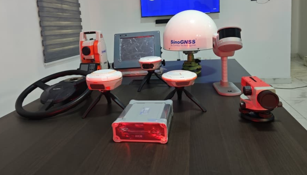
OTIC Geosystems: A Complete Hub for Survey Professionals OTIC Geosystems supplies: GNSS Receivers (RTK Systems) Total Stations Automatic and Digital Levels Laser Scanners (including the LS600 Laser Scanner) Controllers and Data Collectors Survey Accessories We serve professionals across Nigeria, delivering equipment to states including Lagos, Abuja, Rivers, Cross River, Kano, and beyond. Trusted by Leading Construction Companies OTIC Geosystems has supplied GNSS receivers to Craneburg Construction Company, supporting their field positioning requirements on major construction sites.
Additionally, Julius Berger Nigeria Plc acquired the LS600 Laser Scanner from OTIC Geosystems, demonstrating our role in supporting high-level engineering and infrastructure projects. When leading construction firms choose your equipment, it reflects confidence in reliability and performance. Why Professionals Across Nigeria Choose OTIC Geosystems
1. Industry-Focused Understanding We understand Nigerian terrain — coastal, urban, highway, and remote environments.
2. Technical Support & Guidance We provide setup assistance and operational guidance to help teams deploy equipment efficiently.
3. Nationwide Delivery We deliver across major project zones, including Lagos, Abuja, Port Harcourt, Enugu, Kano, Cross River, and Uyo.
4. Structured Online Platform Professionals can browse equipment, submit inquiries, and connect with our team directly via: 👉 https://oticgs.com/
5. Meeting the Growing Demand for Modern Geospatial Tools As infrastructure investments increase and coordinate-based reporting becomes standard on capital projects, demand for: GNSS receivers Total stations Laser scanners Drones Unmanned survey vessels (USV) Echosounders Side scan sonar Payloads Autosteering systems Levels Field accessories continue to rise. OTIC Geosystems ensures professionals have access to reliable equipment backed by local support. Nigeria’s infrastructure growth is accelerating across multiple states, including the Lagos–Calabar Coastal Road, Lagos-Ibadan Expressway, and Second Niger Bridge. Surveyors, engineers, GIS professionals, and contractors need suppliers who understand real field conditions and can deliver promptly. OTIC Geosystems provides dependable geospatial tools to professionals and major construction companies across Nigeria. Visit https://oticgs.com/buynow to explore available equipment and make inquiries.