

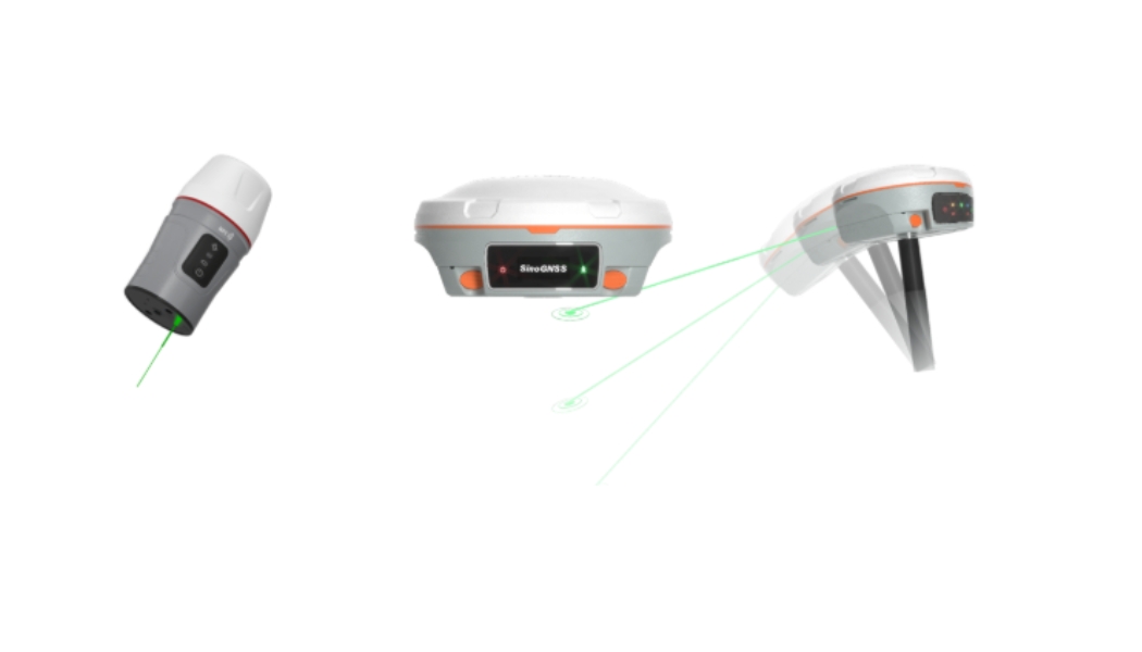
Laser-enabled GNSS receivers are not just hardware upgrades; they are AI-powered survey companions that extend where surveyors can work, how safely they can operate, and how fast results can be delivered.” For years, GNSS technology has steadily improved how surveyors work, from faster RTK fixes to tilt compensation that reduced the need for perfect pole leveling. But today, surveying has entered a new phase entirely, and the conversation around GNSS technology has changed. Interestingly, tilt intelligence is no longer the breakthrough; it is the baseline Modern GNSS receivers are evolving into AI-assisted survey companions, and the clearest sign of this evolution is laser-enabled GNSS technology. This is not just another feature upgrade. It is a fundamental shift in how surveyors measure, where they can work, and what clients expect. And for Nigerian surveyors, this shift is here. From Tilt Intelligence to the Laser GNSS Era Let’s be clear: Tilt compensation is now standard GNSS technology.
Most surveyors are already familiar with IMU-based tilt, which allows points to be measured accurately without keeping the pole perfectly vertical. But laser GNSS goes far beyond tilt. Laser-enabled GNSS receivers introduce an entirely new capability: the ability to measure points you cannot physically occupy. Across fences, inside compounds, over water, along busy highways, or in unsafe industrial zones, laser GNSS removes physical barriers that once slowed down or completely blocked survey work. This leap is made possible not by the laser alone, but by AI-driven intelligence working behind the scenes. How Laser-Enabled AI Works in GNSS (In Simple Terms) It’s important to be precise here: The laser itself is not AI. But laser-enabled GNSS receivers rely on AI-assisted algorithms to make laser measurements accurate, reliable, and survey-grade. Here’s how it works:
1. Intelligent Laser Targeting When a laser is fired, the GNSS receiver uses smart algorithms to: Identify the valid laser target, Filter noise and reflections, and maintain accuracy over long distances (up to 30–50 meters or even more). Without this intelligence, laser measurements would be unreliable in real survey environments.
2. AI-Driven Coordinate Projection Once the laser hits a target, the GNSS engine combines satellite positioning, IMU orientation (tilt and direction), Laser distance, and angle AI-assisted processing then projects the true ground coordinate in real time, ensuring accuracy even when the surveyor is standing several meters away.
3. Sensor Fusion for Error Control Laser GNSS uses sensor fusion, a core AI concept, where GNSS, IMU, and laser data are continuously checked against each other. If geometry is unstable or accuracy drops, the system: Detects it, corrects it, or warns the user before bad data is stored This dramatically reduces human error and rework.
Why Laser GNSS Matters for Nigerian Surveyors Nigeria’s surveying environment presents real challenges: Fenced properties and gated estates Swampy terrain and waterways Busy highways and industrial zones Dense urban developments Laser-enabled AI GNSS receivers allow surveyors to: Work faster with fewer setups Improve safety by avoiding dangerous positions Complete jobs that previously required extra manpower or alternative methods Deliver results clients increasingly expect in shorter timelines In competitive markets like Lagos, Abuja, Port Harcourt, and emerging coastal zones, this advantage is no longer optional; it’s strategic. So, instead of wasting time negotiating access, clearing obstructions, or risking safety, surveyors can measure from a safe position, often up to 50 meters away, with AI correcting and aligning the data in real time. This is not just faster surveying; it is smarter surveying. Laser GNSS in Practice: The SinoGNSS Advantage This is where advanced receivers like SinoGNSS Jupiter, Mars Laser, and Venus stand out. These receivers are designed not just with laser hardware, but with an intelligent GNSS architecture that integrates: Smart tilt compensation Long-range laser measurement AI-assisted data validation Fast RTK initialization Reliable performance in challenging Nigerian terrain They don’t replace the surveyor; they extend the surveyor’s capability. Instead of asking “Can I occupy this point?”, the modern question becomes: “Can my receiver intelligently measure it?” What This Means for Your Practice Surveyors who invest in laser-enabled GNSS receivers gain more than equipment; they gain: Speed, Safety, Precision, Access to higher-value projects, and Long-term relevance. Those who delay risk being limited by tools that no longer match modern project demands.
What This Means for the Modern Surveyor The role of the surveyor is evolving. Clients are no longer paying only for coordinates. They are paying for: Speed, Safety, Accuracy, and Problem-solving ability. Laser-enabled AI GNSS receivers allow surveyors to focus less on physical limitations and more on decision-making, validation, and interpretation, the true value of professional surveying. Surveyors who adopt this technology early will complete jobs faster, win more complex projects, differentiate themselves in a crowded market, and stay relevant as expectations continue to rise. Now Available for Immediate Sale and Delivery At OTIC GEOSYSTEMS, we are not talking about future concepts; these laser GNSS receivers are available now. The SinoGNSS Jupiter, Mars Laser, and Venus are currently in stock for immediate sale and delivery, with local support, training, and after-sales service. The laser GNSS era is here; the only question is whether you will lead it or catch up to it.