The surveying industry is evolving beyond traditional methods of measuring individual points and recording isolated features. Today, professionals can capture entire environments, structures and landscapes in three dimensions, creating detailed digital representations that support planning, engineering, construction and spatial analysis.
One technology driving this transformation is 3D laser scanning.
For modern surveyors, understanding this technology is becoming increasingly valuable. It offers new ways to collect spatial information, improves the level of detail available for project analysis and creates opportunities to work across industries that increasingly depend on accurate 3D data.
But what exactly is 3D laser scanning, how does it work, and what should surveyors understand before investing in the technology?
What Is 3D Laser Scanning?
3D laser scanning is a measurement technology that uses laser beams to capture the shape, dimensions and spatial characteristics of physical objects or environments.
Unlike conventional surveying, where a surveyor may measure selected points using a GNSS receiver or total station, a laser scanner rapidly captures thousands or even millions of points across visible surfaces.
Each measured point has three-dimensional coordinates: X, Y and Z.
Together, these points form what is known as a point cloud—a dense digital representation of the scanned environment.
Depending on the scanner, the data may also contain colour information, laser intensity and other attributes that help users interpret the captured environment.
In simple terms, a 3D laser scanner allows a surveyor to capture considerably more information about a site than measuring a limited number of individual points.
How Does a 3D Laser Scanner Work?
Most laser scanning systems work by directing laser energy towards a surface and measuring the returning signal.
The scanner uses the measured distance, together with horizontal and vertical angular information, to determine the position of each captured point in three-dimensional space.
This process happens extremely quickly, allowing the instrument to collect large volumes of spatial data.
The general workflow involves:
Scanning: The instrument captures visible surfaces using laser measurements.
Point cloud generation: The collected measurements form a three-dimensional dataset.
Registration: Multiple scans are aligned into a common coordinate system.
Georeferencing: Where required, survey control and positioning information connect the scan data to the project’s coordinate reference system.
Processing and analysis: Software is used to clean, classify, measure and interpret the point cloud.
The result can be used to produce 3D models, building measurements, topographic information, cross-sections, digital surface representations and other project deliverables.
One important consideration is that laser scanners generally require a clear line of sight to capture a surface. Hidden areas, corners and obstructed features may require additional scanning positions.
Why Does 3D Laser Scanning Matter to Modern Surveyors?
The value of laser scanning goes beyond collecting measurements faster. It changes the amount and type of information surveyors can provide.
Consider a construction project involving an existing building. A conventional survey may capture selected dimensions, elevations and structural positions. A 3D laser scanner can capture a much denser representation of the building, including visible structural details, surfaces and surrounding features.
This can support:
Construction and engineering: Existing-condition surveys, dimensional verification, progress monitoring and as-built documentation.
Architecture and urban planning: Building documentation, renovation planning and digital modelling.
Mining and quarrying: Stockpile measurement, excavation analysis and terrain documentation.
Infrastructure: Road corridors, bridges, tunnels and utility environments.
Oil and gas: Plant documentation, industrial facility modelling and asset inspection.
Heritage preservation: Detailed digital records of monuments, historical buildings and structures.
For surveyors, this creates opportunities to move beyond conventional field measurements into reality capture, 3D data processing, spatial modelling and specialist surveying services.
Importantly, laser scanning does not make GNSS receivers or total stations obsolete. These technologies complement one another. GNSS provides positioning and control, total stations support precise observations and setting-out, while laser scanners capture dense 3D information about visible environments.
Understanding the Different Types of 3D Laser Scanners
Not every scanner is designed for the same application. Understanding the main categories helps surveyors make better equipment decisions.
1. Terrestrial Laser Scanners (TLS)
These are typically tripod-mounted instruments used to capture detailed environments from fixed positions. They are particularly useful for buildings, industrial facilities, structural documentation and engineering surveys.
Multiple scans can be combined to produce a comprehensive representation of the environment.
2. Handheld and Mobile SLAM Laser Scanners
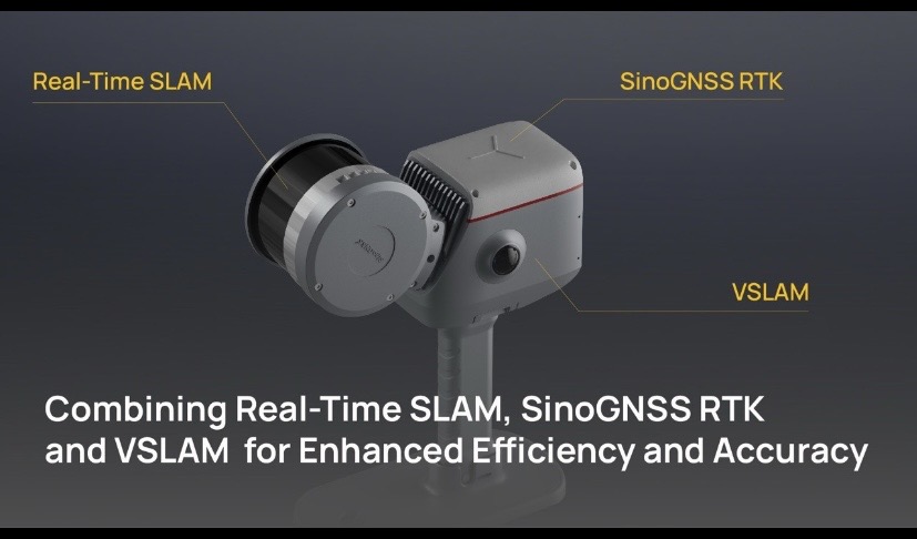
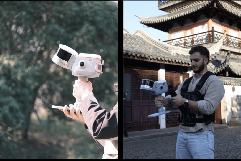
These systems allow operators to walk through an environment while capturing spatial data. They often combine LiDAR, cameras and an Inertial Measurement Unit (IMU), using SLAM technology to estimate movement and build a consistent point cloud.
SLAM stands for Simultaneous Localisation and Mapping. It allows the scanner to map its surroundings while estimating its own position, making it useful in indoor environments and locations where satellite positioning is limited.
3. Vehicle-Based Mobile Laser Scanning Systems
These systems are mounted on vehicles and designed to capture large environments as they move. They commonly integrate LiDAR, GNSS, IMU and distance-measuring equipment to support positioning and mapping.
They are particularly useful for road surveys, urban infrastructure mapping, utility inventories and large-area asset documentation.
Understanding the Specifications Before Choosing a Scanner
A scanner’s specifications determine what it can realistically achieve. Understanding these figures is essential when selecting equipment for professional applications.
Scanning range: This describes the distance over which the scanner can capture surfaces under specified conditions. A longer range may be useful for infrastructure and large environments, but actual performance depends on surface reflectivity, environmental conditions and measurement requirements.
Accuracy: This describes how closely measurements represent the true positions or dimensions of the surveyed features. It is particularly important for engineering, construction and dimensional verification. Always distinguish between absolute accuracy, relative accuracy and repeatability.
Scanning speed: Usually expressed in points per second, this indicates how many measurements the scanner captures within a second. A higher rate can improve field productivity, but speed alone does not determine data quality.
Field of View (FOV): This describes the angular area the scanner can capture. A 360-degree horizontal field of view, for example, allows the instrument to capture its surroundings horizontally, while the vertical field of view determines how much of the space above and below it can record.
SLAM, GNSS and IMU integration: These technologies help establish the scanner’s position and orientation while collecting data. Their integration is particularly important for mobile scanning and georeferencing.
Camera and colour imaging: Some scanners include cameras that add colour information to point clouds, making features easier to recognise and interpret.
Battery life and environmental protection: These affect field productivity. Battery capacity, operating duration, dust and water protection ratings should be considered in relation to the working environment.
Data formats and processing software: A scanner should support practical export formats and software workflows that allow point clouds to be processed and integrated into CAD, GIS, BIM and other applications.
The most expensive scanner is not automatically the best choice. The right instrument is the one whose capabilities match the project’s accuracy requirements, working environment, operational demands and budget.
Exploring Modern 3D Laser Scanning Technology
As laser scanning technology develops, manufacturers are combining multiple sensors to improve data collection, positioning and processing.
Two examples worth exploring are:
ComNav LS600 Handheld 3D Laser Scanner
The LS600 combines LiDAR, SLAM technology, GNSS positioning, an IMU and dual 48-megapixel cameras. It is designed for handheld scanning across indoor and outdoor environments.
Its published specifications include:
Scanning range configurations of approximately 0.5–120 m and 0.5–300 m.
Scanning speeds of up to 320,000 or 640,000 points per second, depending on configuration.
360° × 270° field of view.
Published processed relative accuracy of approximately 1 cm.
RTK positioning support and colour point cloud capture.
These capabilities make it relevant to building documentation, urban surveying, mining and other reality-capture applications.
ComNav ML300 Mobile Laser Scanning System
The ML300 is designed for larger-scale mobile mapping. It integrates dual LiDAR sensors with GNSS, IMU, distance measurement and SLAM technologies.
Its published specifications include:
Detection range of up to 300 m.
Scanning speed of up to 1,280,000 points per second.
360° horizontal field of view.
Published relative accuracy of up to 2 cm.
Absolute accuracy of up to 5 cm.
Integration with panoramic imaging.
It is particularly suited to road mapping, urban infrastructure documentation, power-line analysis, urban forestry and smart transportation applications.
These examples demonstrate how different scanner configurations serve different professional needs. They are not interchangeable: the LS600 is a handheld reality-capture solution, while the ML300 is designed for vehicle-based mobile mapping.
Developing the Modern Surveyor: Skills Beyond Data Collection
Owning a 3D laser scanner is only the beginning. The real professional value lies in knowing how to operate it, manage the data and turn the resulting information into useful project deliverables.
Surveyors looking to develop in this area should build competence in:
Scanner operation, field planning and scan positioning.
Point cloud registration and georeferencing.
Quality control and measurement accuracy assessment.
Point cloud cleaning, classification and feature extraction.
3D modelling and integration with CAD, GIS and BIM workflows.
Interpretation and presentation of spatial data.
These skills can open opportunities in construction, infrastructure, mining, architecture, engineering and specialist geospatial services.
Practical training is particularly important. Understanding scanning principles in theory is useful, but learning to set up equipment, capture data, process point clouds and interpret results provides a stronger foundation for professional application.
Accessing 3D Laser Scanning Technology Through OTIC GEOSYSTEMS
At OTIC GEOSYSTEMS, we recognize that the future of surveying depends on connecting professionals with the right technology, technical knowledge and support.
Our geospatial equipment solutions include modern 3D laser scanning technologies, alongside GNSS receivers, total stations, drone mapping solutions and other surveying instruments.
Through our equipment offerings, professional training and technology-learning initiatives, we aim to help surveying professionals understand not just what modern instruments can do, but how to apply them effectively.
For professionals considering an investment in 3D laser scanning, OTIC GEOSYSTEMS can help identify suitable equipment based on project requirements, technical specifications and operational needs. Flexible payment options may also provide an alternative route to accessing suitable technology, subject to applicable terms.
Explore surveying and geospatial equipment at www.oticgs.com, or contact OTIC GEOSYSTEMS to discuss 3D laser scanning solutions and professional training opportunities.
The future of surveying is increasingly three-dimensional. For today’s surveyor, developing the knowledge to capture, process and interpret that information is an opportunity to remain relevant, expand professional capabilities and contribute to the next generation of geospatial solutions.
OTIC GEOSYSTEMS — WITH YOU EVERY STEP OF THE WAY.